
When the developers of Google Earth made it possible for anyone to send models of real buildings for its 3D world map, they probably had people like Steve Cline in mind.
Cline, who's working toward a degree in geospatial technology from Harrisburg University of Science and Technology, has always been fascinated by maps and architecture. After earning a bachelor's degree in geography from Penn State, he got a job driving one of the original vehicles capturing images for Google's Street View.
A few years ago he started creating 3D models of buildings with a software program called SketchUp and submitted them to Google Earth. And last year he turned that hobby into a business, Urban 3D.
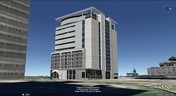
Have you ever seen Google Earth's 3D renderings of buildings at Saint Joseph's University or the Walnut Street Bridge in Harrisburg? Those were Cline's handiwork.
Cline has something unfortunate in common with many of today's twentysomethings: He's been laid off from two jobs since graduating from Penn State University in 2006. So launching Urban 3D was a way for him to avoid meeting that fate again and make a living doing what he loved.
Cline chose three key segments for his business: colleges, tourist attractions and historic landmarks. These are places that visitors often search for on maps before they leave home, he says.
“When you're going on vacation, people have to know how to get there,” Cline says.
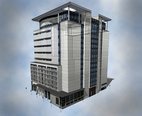
He starts the mapping process by checking out the buildings in person. He takes pictures on location, capturing the building's textures and shapes. He uses these photos to create plain gray images with the shapes of the real structures. Then he adds textures to the gray renderings, transforming them into realistic 3D models.
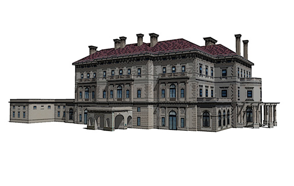
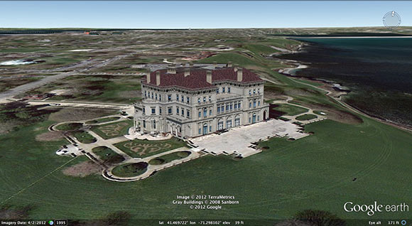
The result is the stunning images he's created for a range of clients. Thanks to Urban 3D, users of Google Earth can virtually visit office buildings in Harrisburg, explore the legendary Gilded Age mansions in Newport, R.I., and tour the campuses of Saint Joseph's and Lancaster Bible College.
Soon after starting Urban 3D, Cline enrolled at Harrisburg University. The college's program in geospatial technology – basically, technologies around the collection of information relative to the earth's surface – would give him the professional contacts and technical knowledge to help his business grow. He expects to graduate with his second bachelor's degree in the fall of 2013.
“It was an opportunity for me to gain the technical expertise and make those business connections,” Cline says.
The university's geospatial technology program is still small, says its lone full-time faculty member, Albert Sarvis. And since Cline is its only student who already has a college degree, he and Sarvis have worked together one-on-one. In addition to his coursework, Cline is contributing to thermal energy pipe mapping project with the new Geospatial Technology Center in Harrisburg.
Students who want a future in geospatial technology must learn how to do more than just build 3D renderings, Sarvis says. They need the skills to figure out how advanced mapping tools can be put to use in industries such as utilities, urban planning, agriculture and environmental science. And Cline recognizes that.
“You can't just know how to make maps. You need to know how to develop applications to use this technology,” Sarvis says. “Steve has the awareness of what he needs to learn, which is one of his critical strengths.”
For now Cline is focusing on his education. As he has more time to work on Urban 3D, though, he plans to develop more applications for his mapping business. He sees ways to improve many of the hard-to-navigate maps on the Internet, making them more intuitive to use by eliminating buttons required to zoom onto specific locations and view panoramic images. And every college could benefit from having a virtual campus map that allows visitors and prospective students to take custom 3D tours.
“It's so essential for a school to have a good map,” Cline says. “Even more than any other page on your website, that page is going to get looked at.”
REBECCA VANDERMEULEN is a freelance writer who lives near Downingtown. As she tells friends out of state, that's between the cheesesteaks and the Amish. Send feedback here.
↑ Top